
Every regional geology significantly differs from others in relation with inner structures, age, rock formations, geo-magnetism, local gravitation and geographical differences such as topography, climate, flora and fauna, overall mineral distribution in the soil etc., no matter even if they are geographically closely connected. In this chapter, I desire to show the clear relationship between regional geologies and language groups in general. The problem of language distributions is not satisfactorily solved as yet. PIE speakers’ migration theories are widely in circulation to explain the spread of the IE languages. The same logic is applied to other language groups such as origination of certain proto-language at some hypothetical land and its disbursal with the movement and spread of the people speaking that language. Genetics too has been used to show the population movements and thus language spread with those movements. Without entering into that endless debate, I wish to propose an alternative theory, which, in my opinion, explains the regional languages and causes of their similarities and dissimilarities with others giving rise to the suspicion whether such net of certain language has been effected because of the population movements as most of the linguists do believe.
I shall show that the population movement is not required for the emergence of certain language, labeled as the grouping of certain languages, such as IE or Dravidian or any other linguistic group for that matter. The hypothesis strongly relies on the following assumptions to which I shall provide sufficient proofs in support.
a) The language is an outcome of the psychological phenomenon. The group of certain people constantly living in certain geographical limits tend to develop their own unique genetic traits that reflect in their general psychology and language which forms a distinct culture as well.
b) Boundaries of every language (dialect) are decided by the specific geological regions.
c) Genetics and language have the certain relationship, though as yet it is undetermined whether faculty of language is innate. It is possible in course of the evolution faculty of language emerged most accidentally in the human being or may have been evolved due to the sudden climatic changes. However, it is essential here to note that the human genome bears the regional markers those are influenced by the local geology.
d) Regional human genetics do vary. The regional markers in the human genome are well detected and have become a matter of debate regarding the early human movements. However, genetics, as indicated by the linguists, just proves ability to learn, develop and speak complex languages. It may not be a factor that determines the origination of the language. However, the geological influence over genetics may be a major factor that shapes particular languages in the certain geological regions.
e) There is the influence of geomagnetism on the human psychologies.
f) General mineral distribution in particular geographies is distinct that influence local crops water, and flora.The people over generations consume them develop the distinct body chemistry. The mineral distribution in the body (and brain) does develop certain psychological characteristics, influencing even their genetic structure.
General observations
a) There is a certain relationship between what and how the language will be developed in the particular regions. With the change in geological formations, from one region to other, we distinctly note the cultural expression and dialect variations. If there are fault regions we can notice entirely different languages, unrelated with surrounding regions, are spoken.
b) Pronunciation Patterns vary region to region, no matter even if they speak the same language.
c) Though Dravidian language speakers are geographically connected with Indo-Aryan speakers, we find clear distinction between the both.
d) Every Indo-Aryan and Dravidian languages again are distinctly different from other regional languages. Within the regions too we find distinct dialects and even contrary to the surrounding language groups! We find regional geological patterns, too, differ wherever we see such linguistic differences/variations.
These are the general observations we should keep in mind. In this article, I will focus on Indian languages those have been divided by linguists as Indo-Aryan and Dravidian.
A fact should be noted that despite the geographical closeness and interaction of millenniums Dravidian languages could not be replaced by otherwise so-called-victorious IE languages though there is and was political and cultural unity to some extent. This is a phenomenon that needs the serious explanation.
Dravidian Language regions
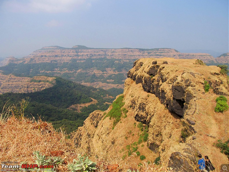
Dravidian languages are spread in south in the four major states, such as Karnataka, Andhra Pradesh, Kerala and Tamilnadu. Interestingly these regions stand apart from rest of the north India from geological point of view as well.
Let us see how. Geological Survey of India has done the extensive study of these states as well. Let us have a look at their findings/observations.
1. Southern Granulite terrain (SGT) covers Andhra, Tamilnadu and southern part of Karnataka.
2. The vast expanse of granulite gneiss terrain covers central and north-east Tamilnadu, referred as “Sathyamangalam” in Tamilnadu is considered to be geological and geographical continuity with ‘Sargurs” of Karnataka.
3. Various types of pink and grey gneisses forming part of the Peninsular Gneissic Complex extend southward from the states of Karnataka and Andhra Pradesh and occur north of Palar River along the northern border of Tamil Nadu. Around Krishnagiri, these gneisses form different textural types of various hues and colours.
4. The southern extension of the Kolar Schist Belt of Karnataka and Andhra Pradesh is seen around Veppanapalli, Maharajagadai and Bargur areas of Dharmapuri District. Within Tamil Nadu the schist belt breaks up into three arms and later extends as dismembered lenses and linear patches within the Peninsular Gneiss. The schist belt is made up of assemblages of greenstone rocks designated as Kolar Group comprising biotite, hornblende schists and amphibolites of different types, banded ferruginous quartzite and acid volcanics (Champion Gneiss) represented by quartz - sericite schist and quartzo feldspathic gneiss.
5. The Pre-Cambrian terrain of Tamil Nadu is extensively fractured and deeply faulted particularly in the northern and central parts. Not all the faults, shear zones and fracture zones have been depicted.
5. There are various groups those vary in age and formations, but are exclusively found in southern states.
6. Karnataka, forming a part of the Indian Shield, is constituted of rock formations ranging in age from 3300 m.y. to 5 m.y. Barring a narrow coastal strip of about 5000 sq.km of Tertiary and Quaternary sediments and another 31,250 sq.km of Deccan basalts, the remaining area is dominated by Archaean-Proterozoic rocks. Mysore Plateau, geologically constituted of Dharwar Craton comprises of greenstone-granite belts, gneisses and granulites.
7. Of Karnataka, components of Peninsular Gneiss always show isoclinal folds with thinned limbs and stretched hinges defined by compositional banding. Viscosity contrast between the quartzo-feldspathic layers and amphibolite mass under the compressive forces have caused a variety of structures. Ptygmatic folds in quartzo-feldspathic materials, agmatitic structures are the few common forms.
8. Greenstone belts of Karnataka have complex geological history and rich mineral resources. The era of 2900 million years to 2600 million years witnessed this great event of the evolution of Greenstone belts in Karnataka. Stratigraphic level vis-à-vis geochronological positioning of different schist belts had always been a point of endless yet useful debate.
9. Of Kerala, geologically, is occupied by Precambrian crystallines, acid to ultra basic intrusives of Archaean to Proterozoic age, Tertiary (Mio-Pliocene) sedimentary rocks and Quaternary sediments of fluvial and marine origin. Both the crystallines and the Tertiary sediments have been extensively lateritised.
10. The rocks of Peninsular Gneissic Complex(PGC) are exposed in the northern parts of Kerala adjoining Karnataka . This consists of a heterogeneous mixture of granitoid materials. The equivalent rocks of PGC in Kerala include hornblendebiotite gneiss (sheared), biotite-hornblende gneiss, foliated granite and pink granite gneiss. Granite gneiss is exposed along the intra-State boundary of Palakkad District as well as in Idukki District.
11. This consists of gneisses showing preponderance of either hornblende or biotite. The percentage of hornblende and biotite varies from place to place. This can be traced from Manantoddy to further northwest up to the west coast. West of Manantoddy, the rock is hornblende gneiss. It shows coarse granulitic to gneissic texture and is composed of hornblende, feldspar, quartz, pyroxene, biotite and garnet. Alkali feldspar shows alteration to clay and sericite. Biotite is mainly secondary after hornblende.
Observations:
All the four states, speaking languages belonging to the Dravidian group, having slightly different local geologies, still having major structural similarities in geological formations. We find that with the slight change in local geology has created separate local dialects. For example, Travankore region has different dialect whereas Palakkad and Trichur region and northern Kerala have different dialects.
So, though there are regional variations in the geological compositions and geography, the overall general geological formation of the southern India is quite distinct from northern India. We will see that difference as follows.
Indo-European Languages
Maharashtra
Maharashtra is a state geographically connected to the Dravidian language speaking regions to south and east and towards North and north-east connected with Indo-European speaking regions. That way Maharashtra can be said as a land that forms middle point clearly separating two distinct language groups.
The entire area of the State forms a part of the “Peninsular Shield”, which is composed of rocks commencing from the most ancient rocks of diverse origin, which have undergone considerable metamorphism. Over these ancient rocks of Precambrian era lie a few basins of Proterozoic era and of permocarboniferous periods which are covered by extensive sheets of horizontally bedded lava flows comprising the Deccan trap. More than 80% area of the State is covered by the Deccan trap, which has concealed geologically older formations. The most important economic minerals such as coal, iron ore, manganese ore, limestone, etc. are found in the geologically older formations.
Structurally, the entire area of the state forms a part of the “Peninsular Shield” of India which represents a fairly stable block of earth crust that has remained unaffected by, mountain-building movements, since the advent of the Palaeozoic era. Some of the subsequent movements in the crust have been of the nature of normal and block faulting which has laid down certain portions bounded by tensional cracks of faults giving rise to basins in which sedimentary beds of the Gondwana age have been deposited.
Particularly in the Vidarbha region giving rise to the important limestone as Penganga beds and coalfields of the Pench-Kanhan valley, the Umred – Bander field the Wardha valley and Vidarbha valley.
It is generally accepted that the Western coast has been formed as a result of the faulting. Along this coast from Ratnagiri to Mumbai, and further north in Thane district there exists a series of hot springs arranged almost in linear fashion which suggests that they are situated on a line of fracture. Further evidence regarding the formation of west coast by faulting is offered by the Western Ghats comprising Deccan trap lava flows, which are several hundred metres thick near the coast and which gradually thins out east wards. Near Panvel, close to the west coast the Deccan traps show westerly slopes designated as Panvel flexure.
Maharashtra has mostly basaltic soil.
The language Marathi is spoken in most of the Maharashtra State, possessing unique characteristics. We also find dialect variation in every geological sub-zones, though they comprise of mostly similar basic structure. In Eastern Vidarbha, we find totally different dialects for those regions has different geological formations and are not part of the Deccan Trap. Also the variations and formations of Konkan strip suggests the probable reasons for the difference in local dialects those posses some alien elements to Marathi.
Madhya Pradesh
The oldest group of rocks comprising of Archaeans and Proterozoic formation constitute nearly 45% area of the State. The next younger formation of Carboniferous to lower Cretaceous comprising Gondwana Super Group covers 10% area while the formation of Cretaceous to Paleocene comprising mostly of Deccan Trap basalt constitutes 38% area of the State.
The state of Chhattisgarh, geographically encompasses an area over 1,35,195 sq km. Geologically, it constitutes important rock formations stratigraphically ranging from Archaean to Recent. Northern Crustal Province (NCP) and the Southern Crustal Province (SCP) separated by EastWest trending Central Indian Shear Zone (CIS) are major tectonic features with crucial geological manifestations.
The regional tectonics have played major role in the tectonic evolution of the Chhattisgarh rocks. The oldest rock in the NCP belongs to the Archaean which includes the granite gneisses and enclaves of igneous and sedimentary rocks confined to southern part of the Province in the Bilaspur-Raigarh belt. Gneisses and granitoids exposed to the east of Mahanadi basin are classified as Chhotanagpur Gneissic Complex. The NCP is devoid of any volcano-sedimentary sequence and Proterozoic cover rocks, unlike the SCP. The younger sequences of Upper Carboniferous to Lower Cretaceous Gondwana rocks are well developed in the Mahanadi and South Rewa basins. The two basins merge in Surguja area north of Baikuntapar. Lameta Group is exposed in the Amarkantak plateau region.
Remnants of Deccan Trap occur in the plateaus in the western and northeastern parts of Bilaspur District and southeastern and eastern part of Surguja District. Laterite and bauxite pockets occur at Jamirapat and Manipatin, Surguja District and Phutka Pahar, Korba District. Quaternary alluvium is confined to major river valleys. The SCP is an Archaean to Neoproterozoic assembly of lithotectonic association comprising Archaean to Palaeoproterozoic Bengpal, Sukma, Bailadila, Sonakhan Groups, gneiss-granitoids and younger Meso to Neoproterozoic cover rocks of Chhattisgarh, Indravati, and Pakhal Groups. Together they constitute the Bastar Craton.
Palaeoproterozoic volcanic rocks of Nandgaon Group extend in a NS direction in to the western part of bordering Maharashtra. The Dongargarh and its equivalent granites in Madanbera and Kanker-Mainpur areas occupy major portion of South Central part of the state. Volcano sedimentary sequence of Khairagarh and Abujhmar Groups and sediments of Chilpi Group belonging to PalaeoMesoproterozoic unconformably overlie the older sequences and the granites in the Maikala Range and Abujhmar plateau region. The Mesoproterozoic Pakhal Supergroup occupies the Godavari valley region in the southwestern part bordering Andhra Pradesh and Maharashtra. The Meso-Neoproterozoic Chhattisgarh Group of rocks occupies the plains of Chhattisgarh region. The cover sediments of Indravati-Sabari-and Pairi Groups are equivalent of Indravati Group and occupy the Jagdalpur plateau. Interestingly we find blend of tribal and Odia culture. Rocks of kimberlite affinity intrude in to the Indravati and Khariar sediments and in the gneisses some of which are diamondiferous. Laterite and bauxite forms cappings at number of places over these rocks in Keskal-Amabera area.
Gujarath
Gujarat exposes rocks from Precambrian era to Holocene period. It has three different geographic regions, namely eastern Gujrat , Kutch and Saurashtra/Kathiawar. The eastern Gujarat shows a general southwesterly and west-ward slope from the dissected and denuded hilly terrain of Preacambrians to the alluvial plain, which gradually merges into the sea and gulf. Shield area of Gujarat lies in the eastern part and is occupied by the Archaean -Prechampaner Gneissic Complex and Prelunavada Gneissic Complex (equivalent to BGC of Rajasthan); Palaeo-to MesoProterozoic Aravalli and Delhi supergroups and Neoproterozoic Godhra-, Erinpura- and IdarGranites. The Mesozoic rocks are exposed in Kutch region and in northern part of Saurashtra Plateau. It is represented by the Pachchham, the Chari, the Katrol and the Bhuj formations in Kutch region and by the Dhrangadhra Group, the Wadhwan Group in Saurashtra Plateau and the Lameta Formation and the Bagh Beds in Kheda, Panchmahals and Vadodara districts (Eastern Gujarat). The Saurashtra Plateau in the west is separated from the eastern Gujarats undulating terrain by alluvial plain. The basalt dominated 'Deccan Trap' with restricted acid and intermediate volcanics and intrusive is exposed as thick pile in the southern part of Gujarat, Saurashtra and as relatively less thick horizons in Kutch Region. It represents broadly the geological time span from 80 Ma to 60 Ma. Tertiary rocks (laterite, clay and carbonaceous shale, lignite etc.) which overlap these volcanics, are present mainly in the southern part of Kutch region, western and southern part of Saurashtra Plateau and also in the area bounded by Narmada and Tapi rivers in the plains of South Gujarat. Pleistocene age of Gujarat is represented by foraminifera bearing aeolian as well as marine limestone. About 50% area of Gujarat is covered by unconsolidated Holocene sediments, majority of which is older and younger flood plain deposits of Narmada, Tapi, Mahi, Sabarmati and Banas rivers. The coastal belt surrounding the Gulf of Kachchh and Gulf of Kutch is dominated by younger and older tidal flat deposits. The state of Gujarat is well known for dinosaurian remains represented by skeletal remains and nests recorded from Kheda district. The state of Gujarat is endowed with a number of mineral deposits viz., bauxite, bentonite, base metals, fireclay, fluorite, fuller's earth, limestone, chalk, glass sand, manganese, graphite, lignite, petroleum and natural gas, building and dimension stones.
Remarks:
The above description is not in minute detail, but it suggests the following-
1) We can see clearly that the geological formation of Dravidian speaking regions stands apart from the geology of the north India. We find Dravidian languages prominently being spoken in the regions those geologically strongly differ from rest of the subcontinent. Though the landmass is connected with northern India, its peculiar formation, age, overall mineral composition and deposits separate it from the north in many ways.
2) The flora and fauna, too, is rather quite different in both the parts of the country. The food habits have been developed since ages owing to its climate and environment, possessing inherently the mineral qualities of the soil, of the southern part of India and elsewhere.
3) Geology of North India, though differs region to region, has unique base formation, quite different than of southern regions. The thrust region created by the collision that caused rising of the Himalayas, underneath has maintained the ancient formations in changed positions. However, we can see other peculiarities about the regions wherever tribal population and distinct languages do exist.
4) We can notice that on the boundary zones, where two typical geologies meet, we find the lingo-cultural changes.
5) It can be said that the major distinction in the geology of both the regions has caused the emergence of different linguistic groups. The same applies to the North-Eastern and North-Western regions where we come across the different geological formations. No any other explanation, such as movement of the people, can be attributed to the formation of the linguistic groups.
6) There is a close relationship between the language spoken and the general psychology of the people living in the certain regions having unique geological conditions for generations.
7) Exchanges or borrowals do influence the course of the specific languages, but that too are adopted in a manner that is suitable to their psychology. The borrowed vocabulary or terms do not remain the same in its original form when adopted but blended in the peculiar local patterns, sometimes so much so that the original form has to be traced with efforts.
Looking at the above, we can surmise that the local geographies and geological patterns are the most influential factors on the general psychology of the people living for generations in certain regions that cause emergence of the certain languages or dialects. The relationship between the languages is not as much biological as it is geological. The land determines the course of the language and the culture as both depend on the general psychology of the people.
We will discuss in the next chapter how the evolution of the languages take place and why some languages completely disappear from the face of the earth, in next chapter. We also will try to solve some other mysteries surrounding the language while going in minute detail of the geological factors.